MT MAGNIFICANT CONSERVATION PARK |
Distance from Adelaide
|
GPS |
Area
|
Number of Bird Species |
|
63 km |
35° 18′ 27″ S 138° 40′ 50″ E |
90 ha. |
61 |
|
How to get there. |
||||
| This park is about 7 km. NE of Mount Compass. From Mt Compass travel east on Nangkita Rd then turn left, travelling 4km along Enterprise Rd, then Blackfellows Creek Rd to the SW corner of the park. By branching right into Mt Magnificant Rd at 3km, and travelling uphill another 2 km on the eastern side of the park another entry point is reached where the Heysen Trail enters on the NE corner. The park can also be reached from Willunga via Meadows Rd. | ||||
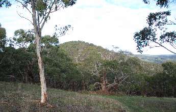
| The park conserves land that was left virtually untouched by the early landholders because of its steep terrain and rocky outcrops. The summit of Mount Magnificent dominates the area, rising 380 metres above sea level. A steep walk through the forest from the NE corner will take you to the trig point, with resultant spectacular views of the surrounding countryside. The trees are mainly Brown and Messmate Stringybark with Pink and Cup Gum. There are steep slopes with rocky outcrops. |
||
 |
 |
 |